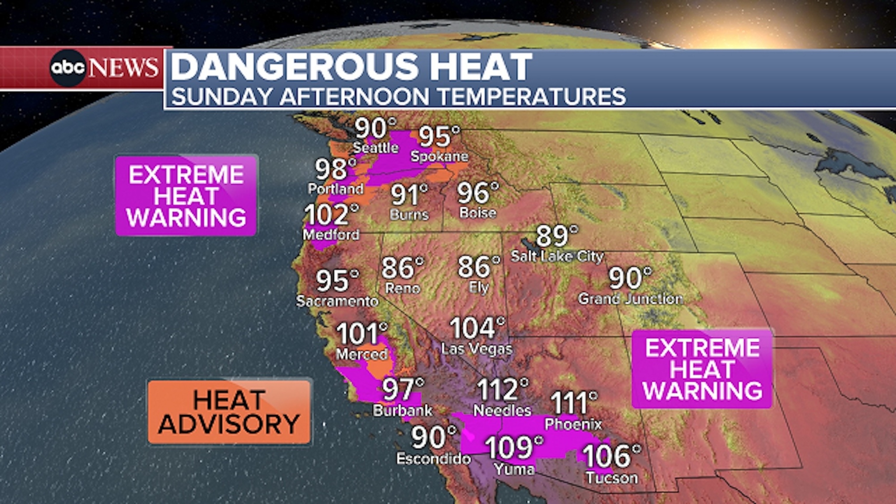
Dangerous heat is impacting more than 30 million people across the West this weekend, with heat alerts in effect from Arizona to Washington.
An extreme heat warning is in effect on Sunday for cities including Seattle, Wash.; Portland, Ore.; Los Angeles, Calif.; Las Vegas, Nev.; and Phoenix, Ariz.
Highs will be near 90 in Seattle on Sunday afternoon and the temperature is expected to soar into the upper 90s in Portland, with daily record highs challenged in both cities through Monday.
A heat advisory is in effect for Riverside and Sacramento, Calif., and Spokane, Wash.
A boy shoots hoops at sunset on August 19, 2025 in San Pedro, California. The National Weather Service issued an extreme heat warning for parts of Los Angeles County which will be in effect from August 21 into the weekend, with temperatures expected to reach 110 degrees in some areas.
Frederic J. Brown/AFP via Getty Images
New daily record-high temperatures were set in several cities in the West on Saturday.
Eugene, Ore., and Olympia, Wash., both set new daily record highs on Saturday, reaching 99 and 93 degrees respectively for the day.
Phoenix also set a new daily record-warm low on Saturday morning, only dropping to 92 degrees, which broke the previous record of 90 degrees set on August 23, 1998.
Temperatures will gradually drop off early this week with more substantial heat relief expected by the middle of the week.
The extreme heat and dry conditions are fueling fires in the West, including the Pickett Fire in Napa County, Calif. The wildfire in Northern California’s wine country started on Thursday afternoon and as of Sunday afternoon had burned more than 6,800 acres and was 11% contained.
Dangerous heat continues, August 24, 2025.
ABC News
Meanwhile, the Flat Fire in central Oregon, which also started on Thursday, had grown to nearly 22,000 acres as of Sunday afternoon and was 0% contained, officials said.
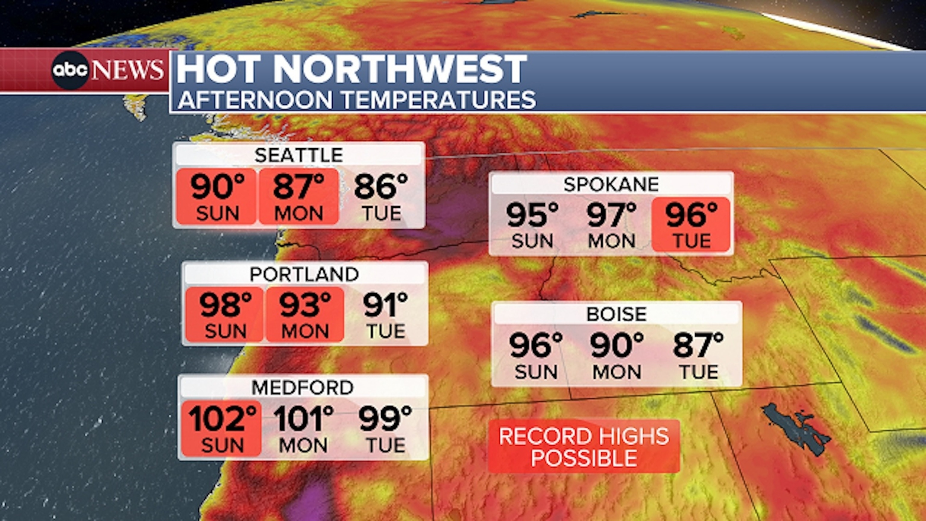
Hot afternoon temperatures in the Northwest will continue into the start of the workweek.
ABC News
Relatively mild temperatures at night across the West will make the heat wave even more dangerous, since the warmer temperatures make it difficult for people to adequately cool off overnight.
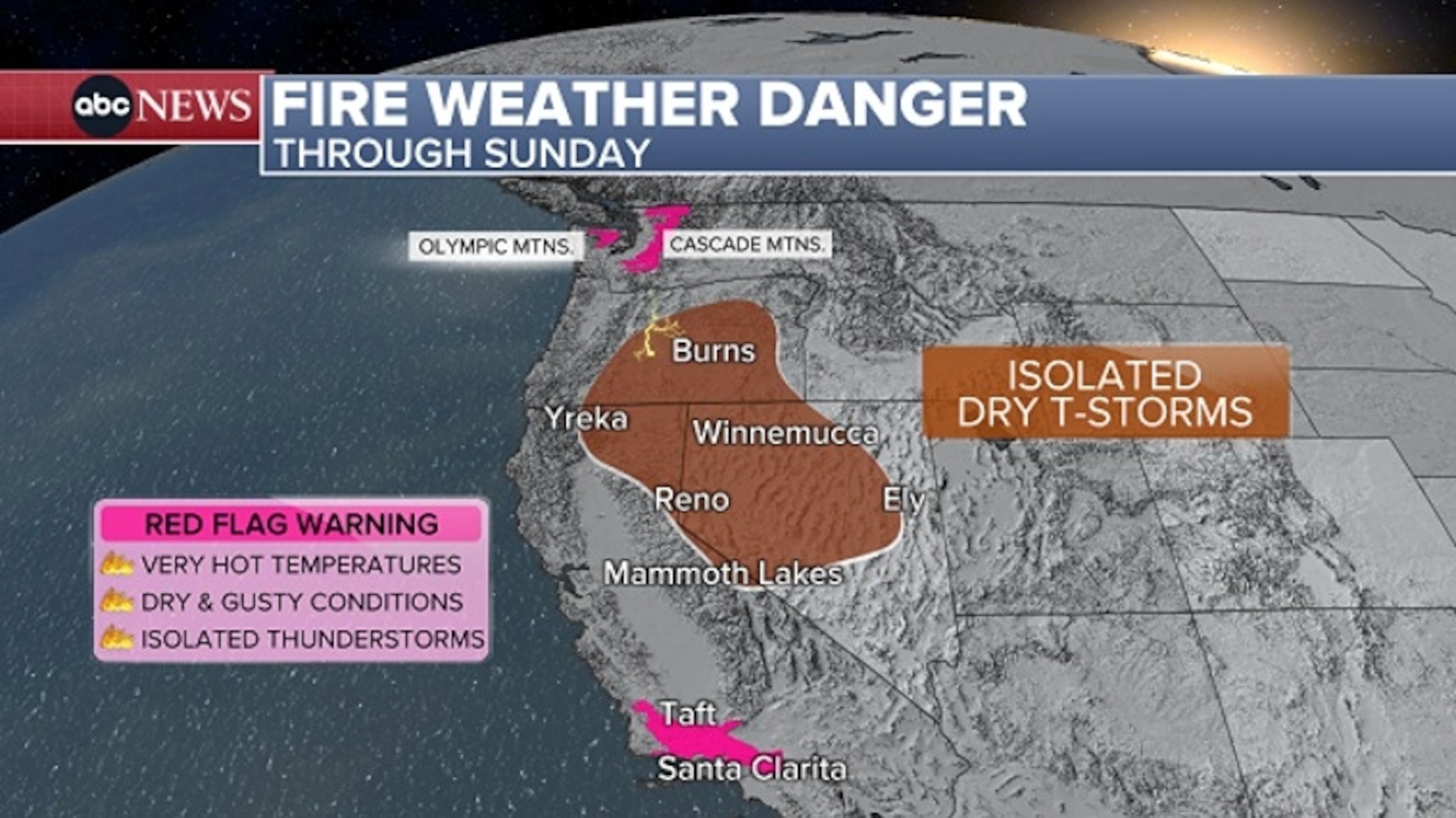
The same pattern that is bringing the extreme heat in the West is also bringing monsoon moisture from the Pacific up across the region. This is fueling more widespread monsoon thunderstorms from the Four Corners region, where Colorado, Utah, Arizona and New Mexico meet, to Southern California. Localized flash flooding is possible in areas forecast to receive the heaviest rainfall. Lightning from these storms could also spark new fires in Southern California, given the the hot and dry conditions in place there.
This expansive and enhanced area of moisture is also fueling isolated thunderstorms in parts of the Northwest. However, most of these storms will bring lightning and little rainfall, prompting red flag warnings for parts of the Cascade and Olympic Mountains in western Washington. Lightning strikes could spark new fires amid very warm, dry and locally breezy conditions.
There also is a disorganized tropical wave in the central Atlantic, located just east of the Windward Islands. While atmospheric conditions there are becoming unfavorable for this disturbance to develop, the National Hurricane Center is currently forecasting a 30% chance of development over the next seven days. It could bring locally heavy rain and gusty winds to portions of the Windward Islands over the next few days.
Tropical Storm Fernand forms in Atlantic
The peak of the Atlantic hurricane season is now less than three weeks away and the tropics remain active behind Hurricane Erin.
The National Hurricane Center is monitoring two tropical disturbances in the Atlantic Basin, though neither of these are currently a major concern or expected to have any impact on the U.S.
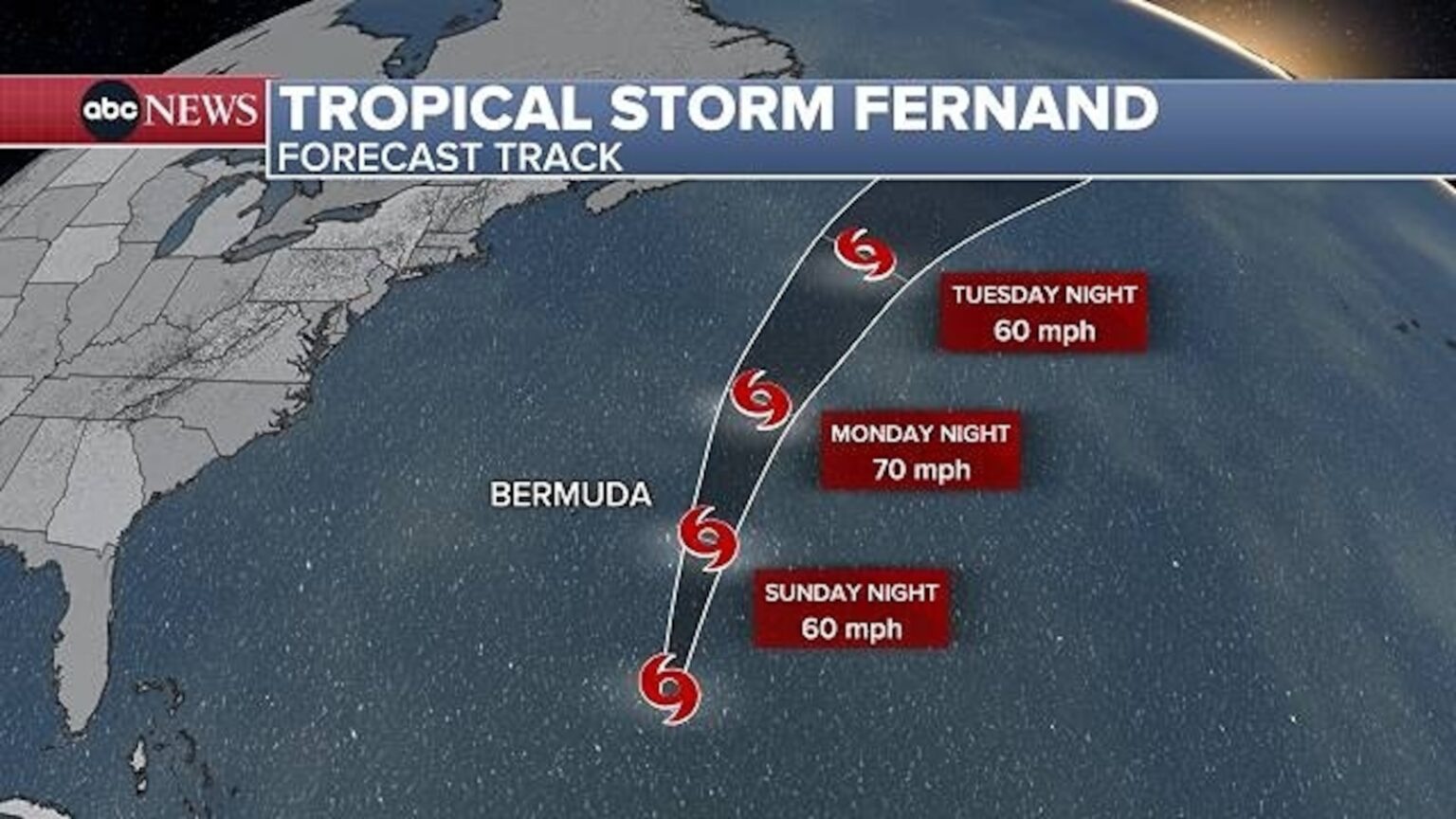
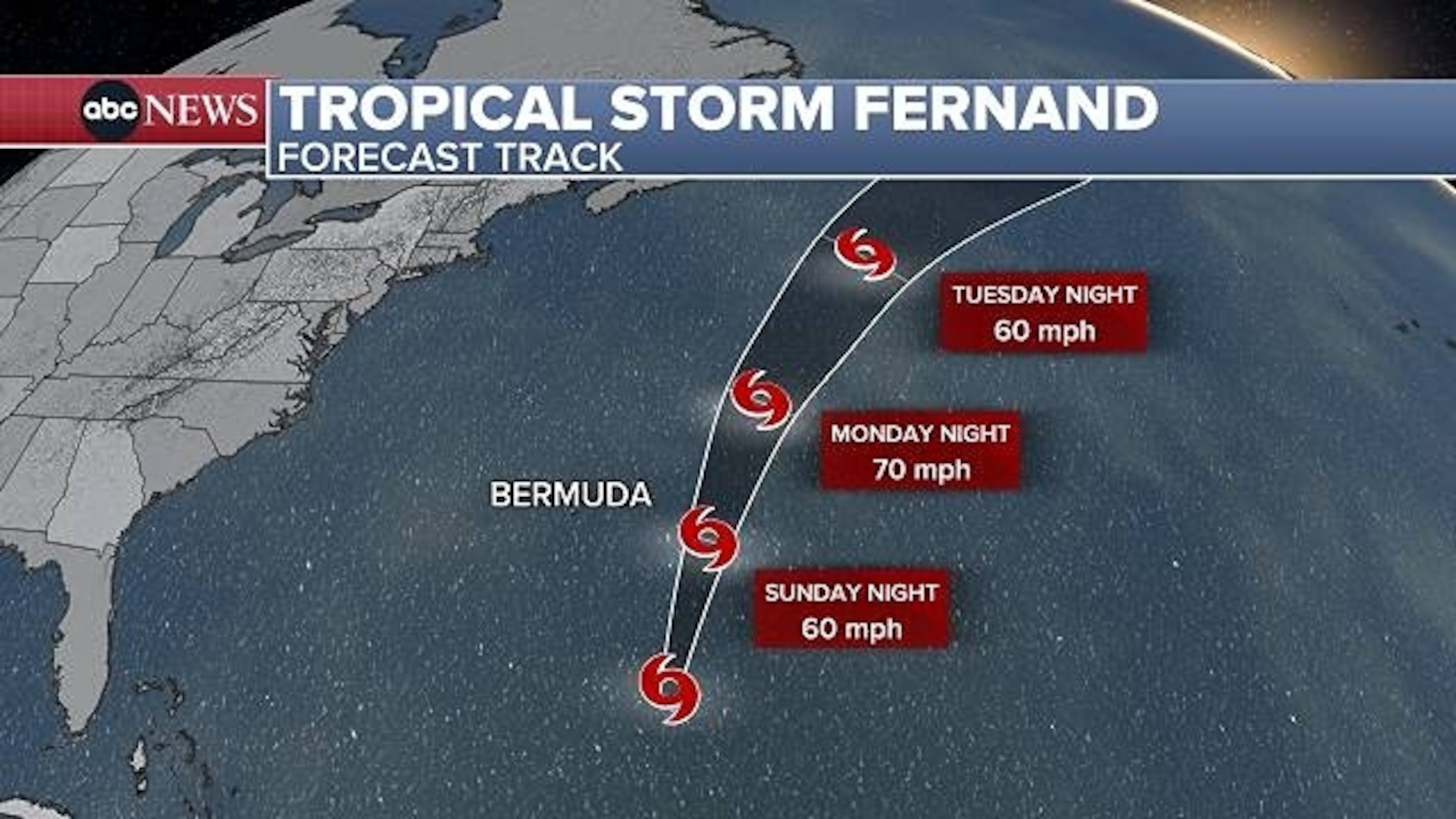
The first disturbance is Tropical Storm Fernand, which formed late Saturday afternoon over the middle of the Atlantic Ocean, several hundred miles south-southeast of Bermuda, according to the National Hurricane Center. Fernand is the sixth named storm of the Atlantic hurricane season.
The storm is forecast to move north over the open waters of the north-central Atlantic in the coming days and to strengthen over the next 24 hours as it passes east of Bermuda Sunday night into Monday.
Fernand is expected to pass far enough east of Bermuda to keep any rain and wind impacts away from the island. However, a period of rough surf is possible early this week as the storm passes the island.
Lingering effects from Erin
Meanwhile, lingering rough surf and dangerous rip currents caused by Hurricane Erin continue to put a damper on many beach plans along the East Coast.
The coastal impacts will continue to gradually diminish throughout the weekend. However dangerous rip currents, coastal flooding and rough surf impacts will persist in many areas.
High-surf advisories remain in effect along parts of the New England coastline, from New Hampshire to Maine.
A significant improvement in beach conditions is expected on Monday, with the high threat for rip currents not expected to be as widespread for the East Coast as it has been in recent days. While there could still be localized areas facing a high risk, overall ocean conditions will diminish even more on Monday.
The post More than 30 million on alert for dangerous heat appeared first on abcnews.go.com

